Russian Meteor Explosion Seen From Space
The meteor that exploded in the stratosphere over Chelyabinsk, Russia, in February this year had photographers and videographers from across the Ural Mountain region on its trail.
But what if it had occurred over the ocean? Or in a region with fewer photographers at the ready?
Thanks to the documentation of Russia’s superbolide experience, which tragically injured more than 1200 people with its destructive shockwave, the details of the meteor strike have helped atmospheric scientists ground-truth the trajectory and velocity of the event calculated with data from several Earth-viewing environmental satellites in both geostationary and polar orbits. They reported their findings today in the Proceedings of the National Academy of Sciences.
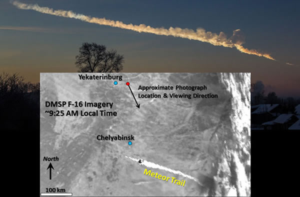
The meteor explosion created a flaming debris trail that lit up the sky over Russia and came careening towards Earth at a velocity of 17.7 ± 0.5 km/s (about 11 miles per second), reported Steven Miller of Colorado State University and colleagues from the University of Wisconsin-Madison. The satellite imagery of the meteor trail shows it to continue for a distance of about 212.1 km (131.7 miles) while the video footage from the ground showed the formation took place within about 12 seconds.
At the point of the sonic blast, a convective “turret” is seen in the meteor trail and thermal infrared satellite imagery indicates the temperature of the trail at this point was -67 degrees Celsius (-88.6°F), placing it in the middle stratosphere (about 25-30 km or 15 to 19 miles above Earth’s surface).
With several satellites monitoring the event, and each with its own perspective, assigning a trajectory to the meteor provided the atmospheric scientists with an extreme case of what happens when high-altitude objects are being viewed at high observer zenith angles, producing what’s called a “parallax effect,” when every perspective seems to give a different answer as to what the trajectory really should be. Usually this isn’t a problem when dealing with meteorological events, “for most tropospheric clouds and viewing conditions, parallax effects are minor,” the authors report.
But by knowing the exact location of each satellite the scientists were able to remove the displacement problems. Miller and his team concluded that the Russian meteor had a 282.7 ± 2.3° azimuth of trajectory, with a 18.5 ± 3.8° slope to the horizontal, which they report “compared favorably” with estimates based on photographs and video documents of the event. The trajectory also indicates that the meteorite pulled out of Lake Chebarkul did not travel in a straight line, but rather decelerated as it fell through the lower atmosphere in a parabolic descent.
“These Earth-viewing environmental satellites have demonstrated their value as a useful, albeit unconventional, tool in trajectory reconstructions,” the team reported. So the next time a chunk of space rock comes hurtling into Earth, even if nobody sees it happen, our ever watchful satellites could be used to keep us informed ― which leaves me to ask are there archived images available of events we may have missed?
IMAGE: Photograph of meteor trail near Chelyabinsk, Russia, on Feb. 15, 2013, at about 9:21 AM local time, with corresponding DMSP satellite image from about 9:25 AM. (Photograph courtesy of Alex Alishevskikh, satellite image courtesy of Steven D. Miller, Colorado State University.)(Oct 21, 2013 03:00 PM ET // by Christina Reed)