From Our Archives: Tornado!
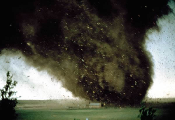
A tornado blasts through a mobile-home park near Cheyenne, Wyoming. Watching from a quarter mile away, Peter Willing took this photograph just before rushing to his basement; he lived to tell the story.
Editor's Note: This article was originally published in the June 1987 issue of National Geographic magazine.
Hailstones rapping on her bedroom window woke Kimberly Lewis one April morning last year in Sweetwater, Texas. Her husband, Terry, had left for the gypsum plant half an hour before. Two of her children, Nathan and Ashley, were sleeping beside her. Eleven-month-old Amanda was in her own room.
"I looked out the window and saw a couple of garage doors fly across our backyard and my heart froze," she said. "I tried to go get Amanda, but I never made it."
Windows shattered, the bedroom floor tilted, and the ceiling collapsed. "Next thing I knew, I was outside in the rain." Struggling to see without her glasses, her gown ripped off by the winds, she saw Nathan and Ashley stumbling near the wreckage of the mobile home. They were covered with small cuts and bruises, but otherwise were uninjured. But where was Amanda?
"I can't find my baby!" she cried to her uncle, John Brown, who came running down the street from his house. Debris lay scattered across the neighborhood. Carpet was draped around trees. Pieces of the roof were blown across the street. Furniture, clothes, and magazines were strewn over the yard. In the middle of the road was the crib in which Amanda had been sleeping. It was twisted like a pretzel.
Neighbors arrived to help John search through the rubble. In anguish he lifted one piece of wall after another. Then he found Amanda. She was wrapped snugly in her crib mattress, unharmed except for a few scratches near her right eye.
"She never made a sound," Kimberly said. "She just held out her arms."
There had been no warning of the tornado that ripped through Sweetwater that morning, destroying 161 homes, injuring 92 people, and taking the life of an 87-year-old man. There had been no time to sound the town's sirens. No tornado reports had been broadcast on television or radio. Local weather radar had indicated nothing unusual about the storm until it was too late.
The tornado had struck with the suddenness that makes all tornadoes so terrifying. In a few moments of violence it changed hundreds of lives.
It may soon become possible, however, to avoid such disastrous surprises. Weather forecasters, using advanced technology such as Doppler radar, satellite pictures, and high-speed computers, are learning how to predict strong tornadoes as much as 20 minutes before they occur. With this advance warning, residents of towns like Sweetwater could gain a fighting chance to find safe shelter.
The stories that came out of Sweetwater were like many others in a region where tornadoes are a way of life.
"I was looking to the southwest when I saw clouds coming together from opposite directions," said patrolman Joe Don Smith of the Sweetwater Police Department. Smith had taken a position near Interstate 20 after an earlier tornado sighting.
"The rain and hail had stopped, and it was starting to get light. I was talking on the radio when I looked back and saw a short, fat tornado just materialize a mile away. Then a sliver of another funnel appeared at the side, and the big one sucked it in."
Smith reported the tornado to headquarters, then drove to a nursing home to warn its residents. As he headed back into town, the whirlwind almost caught him. "Debris was swirling everywhere. Pieces of metal hit power lines. Insulation and dust filled the air. I crouched as low in the car as I could, for fear of something coming in a window. It lasted ten seconds, and then it moved on."
The tornado cut a path about a block wide and two miles long through a densely populated part of Sweetwater. Bill Swindle was in his tire store when the tornado roared by. It tore off the roof of the store and sucked out about 200 radial tires. "Most of which I haven't seen since," said Swindle.
Linda Sharp was watching cartoons on television with her nine-year-old son, Michael, when the windows of her mobile home cracked and a roar came through the front door. "I said to Michael, 'Come here, baby,' and we rolled onto the floor between the couch and the coffee table. Michael asked, 'Mama, are we going to die?' and I said, 'I don't think so, honey.' And then we took a little joyride in the house." The double-wide trailer skidded 24 feet across the front yard before coming to a stop. "I could feel the house moving, and we just went with the flow," she said. "I didn't open my eyes, that's for a fact."
The tornado left the people of Sweetwater in shock. It severed power and telephone lines, knocked out the radio station, broke water pipes, and blocked roads with trees. Friends and neighbors checked up on one another while police and rescue squads searched through collapsed houses. In addition to the one fatality, there were 21 injuries requiring hospitalization.
There were also lighter moments. Police officer Ray Carnathan arrived at an accident where a car had been blown off the road into a tree. Its rear windows were gone. "A highway patrolman was helping a woman out of the front seat," said Carnathan. "There was a kitten lying on the back seat, all wet. So I told the woman we would take care of her cat for her. And she said, 'I don't have a cat!' Then this fellow came walking down the street holding two other kittens and looking for the third one."
For all its destruction the Sweetwater tornado was not especially powerful compared with some of the 850, on average, that rumble across the United States each year. Swirling over the Texas plains, it struck Sweetwater with winds of 150 miles an hour or more.
The highest tornado winds ever clocked registered 230 miles an hour, but that's a limitation of instruments. Gauged by the damage in its wake, the tornado that blasted Niles and Hubbard, Ohio, and Wheatland and Mercer, Pennsylvania, on May 31, 1985, carried winds estimated at 260 mph or more. Such monster twisters are rare, but they do the most killing, taking more than two-thirds of the hundred or so lives lost to tornadoes in the United States each year.
The U. S. suffers more tornadoes than any other nation. Cool, dry Canadian air channeled eastward by the Rockies collides with warm, moist air washing north from the Gulf of Mexico, triggering the chain of events that leads to violent thunderstorms.
The tornado season generally begins in early spring in the Gulf Coast states, where twisters tend to be fast-moving and long-lived. Then, as the jet stream shifts northward during spring and early summer, severe weather moves into Tornado Alley, a belt of the central plains from Texas to Nebraska. Here tornadoes tend to be slower and short-lived, though more numerous. Texas, Oklahoma, and Kansas endure nearly a third of all U. S. tornadoes. As summer progresses, storms roar north into the Dakotas and Great Lakes region.
Much of what has been learned about tornadoes in recent years has come from scientists at the National Severe Storms Laboratory (NSSL) in the heart of Tornado Alley in Norman, Oklahoma. Every spring since 1972 researchers from the lab, often in cooperation with teams from the University of Oklahoma, have driven vehicles into the teeth of violent thunderstorms to gather information unavailable anywhere else.
One of their goals has been to drop a barrel of instruments in a tornado's path. The 400pound barrel, dubbed TOTO (Totable Tornado Observatory) for Dorothy's spunky little dog in The Wizard of Oz, is fortified to measure temperature, wind speed and direction, and atmospheric pressure inside a tornado's core. So far, no tornado has directly hit TOTO, though a small one sideswiped it in April 1985.
From their encounters with tornadoes, NSSL teams have made some important observations. They confirmed that strong tornadoes almost always appear on the rainfree rear sides of severe thunderstorms, which typically move from southwest to northeast. Such tornadoes usually descend from a wall cloud, which hangs like a great horizontal wheel from the flat base of the storm. This wall cloud, half a mile to six miles in diameter, is part of a huge, rotating cylinder of air called a mesocyclone, the true source of the tornado's power.
Every April and May NSSL researchers spend hundreds of hours racing across western Oklahoma roads. It is far more difficult than you might imagine to catch a fastmoving thunderstorm in the act of spinning out a tornado. In a two-month season tornadoes may touch down within the 200-mile range of the lab's vehicles on only half a dozen days, and chasers must guess hours ahead of time where they might appear.
All of which adds to the excitement when a team succeeds in catching a tornado-or when, as happened when I joined them last year, a tornado nearly catches them.
May 14, 1986, 11:30 a.m. At NSSL headquarters in Norman, meteorologist Carl Hane tells a dozen or so members of the tornado intercept team that the day's outlook is mixed. The National Severe Storms Forecast Center in Kansas City has issued a tornado watch for the Texas Panhandle and western Oklahoma, and a band of storms is already moving across the area. "But winds are quite weak just off the surface," he says.
At the same time, balloon soundings show that the atmosphere is potentially very unstable. Warm, moist air at the surface is trapped beneath cooler dry air, threatening to explode upward into new thunderstorms if given the right push. This push might come from the afternoon sun, as air near the surface heats and becomes more buoyant. Or it might come from a disturbance in the high-flying jet stream, which could pull up air beneath it. A reading of minus 1 on the "lifted index," a measure of atmospheric instability, means storms are likely to be weak. A minus 5 indicates strong storms. Today's reading is minus 10.
1:15 p.m. The chase team's small caravan pulls away from the lab-two white Dodge vans, dubbed NSSL 1 and NSSL 2, filled with cameras and instruments to measure electrical activity; the tan Dodge pickup truck that carries TOTO; and finally the blue Bronco II in which photographer Chris Johns and I follow, aided by Travis Tull, a veteran storm chaser.
"We've got lots of storms in western Oklahoma, but none major," says Don Burgess, an NSSL tornado expert staying behind to coordinate the chase by radio. "I think we should opt for heading farther southwest and hope for a dominating storm later on."
So the caravan heads southwest, ignoring the thunderstorms closer by on a gamble that the day's worst weather is yet to come.
1:30 p.m. As we near Chickasha, Oklahoma, Burgess radios that the latest infrared satellite image shows an expanding storm near Hobart, 60 miles west. The storm's cloud top appears cold to the satellite's heatsensitive eye, indicating that it has risen to perhaps 60,000 feet-high enough to be interesting. NSSL's Doppler radar also indicates that the updraft has begun to rotate, the first step in producing a tornado.
Like all radars, Doppler sends out electromagnetic signals and picks up echoes from objects in its path. But unlike others, it can measure the shift in frequency between the signal it sends out and the echoes that come back from rain, insects, or other airborne particles. That shift can reveal whether winds are moving toward the radar or away from it, and at what speed. The Doppler soon shows weakening rotation in the Hobart storm-a false alarm.
2:40 p.m. A tornado is reported on the ground near Amarillo, Texas, 200 miles away. Passing through Lawton, our caravan heads west on Route 62. The Doppler still shows no significant rotation in nearby storms. But the chase is heating up.
3:10 p.m. A tornado warning is issued for Jackson County to our west, telling residents to take shelter. We are driving under the leading edge of this storm, which hangs like a huge canopy over hundreds of square miles of flat farmland. The edge is bright white and sharp, a sign that the storm is still expanding and packs real punch.
"We have Doppler showing a mesocyclone in the storm near Duke," reports Lou Wicker, who is helping plan strategy in NSSL 2. We are only 30 miles away, approaching the storm from the east, a good position for intercepting a tornado.
3:30 p.m. "Tornado on the ground, people!" Lou shouts over the radio. "Get your cameras ready. Southwest of us!" I scan the cloud base but can't see a funnel. Hail bangs on our roof and windshield. NSSL 1 moves ahead on the main highway as the rest of us turn left onto a paved farm road and speed south, then west onto a dirt road toward where Lou had seen the tornado. The hail stops as suddenly as it started.
"This thing has two wall clouds," says Lou. "Let's give ourselves a bit of room. We may have to turn around fast."
Getting out of our vehicles, we study two lowered cloud bases, one to the west, the other to the southwest. The tornado apparently has dissipated. But another may soon take its place. The atmospheric pressure is dropping ominously.
"Look at the acceleration going on up there!" says Lou, pointing to the shreds of clouds dancing above us. "That's the old mesocyclone. It's hanging tough."
"It's so large, you could get a spin-up anywhere," says Mike Eilts, driving NSSL 2.
3:40 p.m. We jump back into our vehicles and turn around, driving east to keep in front of the wall clouds. A tornado suddenly touches down two miles behind us. There is a swirling on the ground, then a faint, thick funnel cloud forming around it. The funnel lasts less than a minute and disappears.
"Bust south!" Lou shouts over the radio. "Be ready to deploy TOTO!" It normally takes the TOTO team less than a minute to roll the large canister down ramps on the back of the truck. But often there isn't even a minute to spare, as I was soon to learn.
3:47 p.m. A tornado reappears on our right, surrounded by a spinning wall of rain, and we race south to stay ahead of it. The winds around us are feeding it, sucking up dust and tumbleweeds. We turn east onto a dirt road to keep out of the tornado's grasp. But suddenly we run out of road.
The vehicles ahead of us hit their brakes, stopping in the yard of a farm where a man in overalls is watching us curiously. We spin around to head back toward the tornado and our only escape route-a small road heading north about a quarter mile away. Instantly it becomes clear that we are in real trouble.
"Geez, the rain curtain is wrapping around itself," says Travis, who has been busy driving the Bronco II and hasn't had a chance to take a good look until now.
"Go, go, go! Floor it!" yells Lou. "We got to get out of here!"
The TOTO pickup is first, the NSSL 2 van second, and we are last in turning the corner onto the northbound dirt road. The tornado races toward us across a wheat field. Debris explodes from the ground where the gray wall meets the earth as it rapidly eats up the distance between us.
The rain curtain catches us, splattering rain against our back window as we bounce down the road, but the tornado just misses us. If anything, its strong winds help shove us out of danger.
Behind us at the farm, the twister strikes, stripping roofing from the house, turning over farm equipment, plunging timbers into a shed's roof, and pushing the barn six inches off its foundation.
It wasn't a very powerful tornado. But it was strong enough to flip over a tractor or a vanful of tornado chasers.
"We were lucky," says Travis.
We saw four tornadoes in all from that same storm. Each formed rapidly from a low-hanging wall cloud and survived on the ground for a few minutes or less. As they demonstrated their power, they also revealed their vulnerability. Though tornadoes may seem indestructible, they are usually being unraveled by the same forces that create them.
Tornadoes result from a delicate set of circumstances. Assuming many shapes-from along, thin rope to a fat, inverted bell-they may be as narrow as 50 yards or as wide as a mile. The strongest are spawned by a breed of thunderstorm called a supercell, the "atmosphere's equivalent of a rogue elephant," in the words of Bob Davies-Jones of NSSL.
Like other thunderstorms, a supercell pulls in warm, humid air from the surrounding countryside and propels it aloft through a powerful updraft. The moisture in the updraft condenses into rain, causing a cool downdraft. In ordinary storms, the updraft turns into the downdraft, and the storm collapses. But in a supercell the updraft and downdraft are separated so that one reinforces the other, sometimes for hours.
To make the updraft begin to rotate, the atmosphere surrounding the storm must contain substantial wind shear-change in the speed or direction of the wind with height. When this wind shear is present, strong upper-level winds cause weaker ones below to roll into a horizontal tube. As air rises into the updraft, the tube bends upward, tilting the storm's rotation toward a vertical axis. (painting, next pages.)
When the updraft rotates rapidly, it becomes a mesocyclone, which narrows and intensifies as it stretches upward and downward through the storm. This massive column of swirling air may reach 60,000 feet, yet still not produce a tornado. "Only half of all mesocyclones result in tornadoes, and we can't explain yet why one does and another doesn't," said Davies-Jones.
What gives developing tornadoes their crucial, last-minute spin? To pursue this question, Joseph Klemp and Richard Rotunno simulated a working supercell in a powerful computer at the National Center for Atmospheric Research in Boulder, Colorado. They focused on reports from storm chasers that a tornado usually does not occur until a small downdraft appears on the rear flank of the storm. "Our models show that the downdraft is pulled toward the earth by a sudden increase in the rotation of surface winds," said Klemp. But what causes the added rotation?
The two scientists think it comes from winds flowing into the storm along a boundary between warm and cool air. On one side, warm air rises, on the other, cool air sinks, making the winds passing between spin like a corkscrew. "As these winds swing around the back of the mesocyclone, their rotation is turned up into the updraft," said Klemp. "This extra spinning may trigger a tornado."
Once established, the strongest tornadoes can grow large enough to form smaller ones within them-a discovery made by T. Theodore Fujita of the University of Chicago. These suction vortices, as he calls them, concentrate the twister's power into even more deadly engines of destruction.
Most tornadoes don't survive that long, as I saw during our chase last May. For even as the funnel cloud descends, cool air from the downdraft may wrap around it. If that cool air completely surrounds the tornado, it can choke off the warm air rushing into it. Then the funnel runs out of fuel.
During the brief time that most tornadoes are on the ground, they can perform bizarre feats, leaving chickens featherless, or driving fragile straws into telephone poles. The brute force of the wind may manage this trick by prying open the wood grain, which then slams shut after the straw has entered.
But more often than not, tornadoes are simply terrifying. On April 27, 1986, an Iowa tornado sucked a four-year-old girl out of the pickup truck in which her family was fleeing. On May 31, 1985, a six-year-old boy in Pennsylvania was crushed in his mother's embrace as she tried to shield him beneath a collapsing cellar wall. He was one of 12 people killed when a monstrous tornado nearly wiped their town clean. Seven people died this past February 28, when a twister ripped through southeastern Mississippi.
Such heartbreaking stories fill the chronicles of tornadoes in this country. During the afternoon and evening of April 3 and the early morning of April 4, 1974, a super outbreak of 148 tornadoes descended on 13 states, killing 315 people (map, page 705). The single most deadly tornado on record claimed 689 lives in three midwestern states on March 18, 1925, 234 of them in the town of Murphysboro, Illinois.
Can we do anything to protect ourselves and our homes from such terrors?
"If you're talking about houses, I really don't believe we can-anything that is economically feasible-to prevent the kind of damage we saw at Sweetwater. That tornado was too intense," said James McDonald, a civil engineer at the Institute for Disaster Research at Texas Tech in Lubbock. "But there are a few things we can do to minimize damage from weaker tornadoes, and that's the vast majority of them."
Inexpensive strap anchors over the rafters, for example, can help keep a roof from lifting off, he said. For less than $100, such anchors can provide three to four times the strength of nails alone. And keeping the roof attached is crucial, because without it walls are more likely to collapse.
The greatest threat to individuals comes from flying objects such as broken glass, pipes, and lumber. "Hundreds of pieces of two-by-fours were scattered all over at Sweetwater," said McDonald. "If you got caught in the open with those things flying around, it would be disastrous."
To test the strength of building materials against such missiles, McDonald shot twoby-fours out of a cannon at various types of walls. The red-barreled cannon, housed in the basement of the university's Civil Engineering Building, used compressed air to propel a 12-foot two-by-four at 100 mph.
"We found that the two-by-four will perforate most wall coverings-timber, lapboard, aluminum siding, and the like," he said. "But not a wall with a brick veneeronly a single brick thick."
Such tests helped McDonald design a low-cost inhouse shelter for homes without basements. "We recommend a reinforced concrete masonry wall that is well anchored to the foundation and has a good solid roof, usually a reinforced concrete slab. The idea is that the rest of the house can blow away and that little module will still be there."
In the absence of a basement or shelter, families should go to a small room, such as a closet or bathroom, at the center of the house on the lowest floor. "You want to put as many walls as possible between you and the outside," said McDonald.
Don't bother opening windows to keep your house from exploding, he said. "That's a myth as far as we are concerned. Houses have enough natural openings to keep pressure from building up rapidly. They don't explode. If you opened a window in the windward wall-and you never know where that will be-you could make the situation worse."
The best protection, of course, comes from being forewarned. In today's war against tornadoes, the first alerts come from the 17th floor of the Federal Building in Kansas City, Missouri. Here meteorologists at the National Severe Storms Forecast Center keep a watchful eye on atmospheric conditions across the lower 48 states, using a unique, five-year-old computer system called the Centralized Storm Information System (CSIS). It gathers information from satellites, balloons, radar, and hundreds of weather stations, organizes it, and displays it on video terminals.
If forecasters are concerned about how the weather is developing in, say, southern Kansas, they ask the computer for a fresh satellite image of the area. They may call up a rapid display of images made over several hours, to spot developing weather patterns.
Computer-generated weather maps can be superimposed onto the satellite image, as can data from local weather stations on temperature, humidity, precipitation, and wind speed and direction. To determine the stability of the atmosphere, graphs of upper air data from balloons can be displayed.
If the forecasters suspect that severe thunderstorms or tornadoes will hit southern Kansas within six hours, they issue the appropriate weather watch to local weather offices, the media, and spotter networks, including amateur radio groups.
Despite the technology at their fingertips, the decision to issue a tornado watch always falls on human beings. "There comes a time when numbers don't tell you enough and you have to make a judgment call," said Bob Johns, a lead forecaster at the center. With the safety of large populations resting on his shoulders, Johns describes his job as one of the highest pressured in the Weather Service. "On a typical spring afternoon when I start my shift, the war is going on all around me. I have to get into gear fast. I have to distinguish very quickly situations that are life threatening from those that are marginal."
The center's record for predicting tornadoes is steadily improving. During the past few years, almost all the most violent tornadoes have occurred within watch areas. But many smaller, less damaging tornadoes still elude the forecasters.
"We get about 100,000 thunderstorms a year in the U. S.," said Frederick P. Ostby, director of the forecast center. "Only one percent spawn tornadoes, and two percent of the tornadoes claim 70 percent of the fatalities. What we're trying to do is get a handle on where those 20 or so killer tornadoes will appear and put a watch out two to six hours ahead of time. That's a tough job."
To help local forecasters do their part, the Environmental Research Laboratory in Boulder, Colorado, has been developing a computerized work station under the Program for Regional Observing and Forecasting Services (PROFS). The work station is a prototype of equipment the government plans to install at weather offices across the nation during the 1990s.
Besides providing many of the rapid sources of information available with CSIS-satellite images, radar, surface observations, and balloon data-the PROFS system also takes advantage of two new advances in weather technology.
One is the wind profiler, an automated radar unit intended to complement balloon soundings in reporting wind direction and speed at different altitudes.
The other advance is Next Generation Weather Radar (NEXRAD), a computerized Doppler system that tracks and analyzes storms, especially those with mesocyclones, better than conventional radars.
From the time a mesocyclone is detected on the Doppler radar screen, 20 minutes or more may pass before a strong tornado touches down. That should give local forecasters a crucial head start in warning communities to take shelter.
Armed with such advanced technology, local forecasters will be better prepared for all sorts of local weather problems, from flash floods to heavy snows. But the speed and accuracy of these computerized systems will help them most in their lifesaving fight to sound an accurate alarm-when skies turn black and clouds begin to swirl-that a killer tornado is on its way.
Peter Miller
National Geographic News
Published June 4, 2013