East Coast Tsunami: What's the Risk?
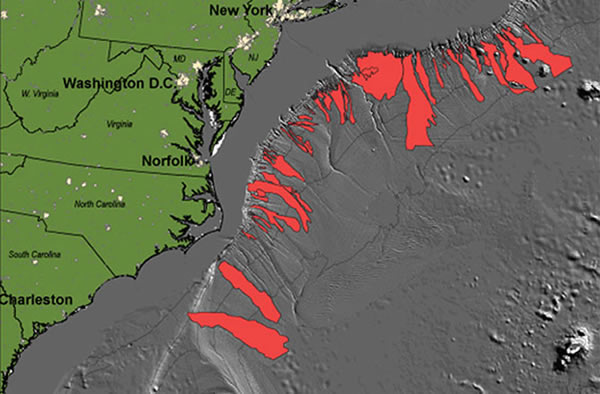
Historical undersea landslides in the Hudson Canyon, off the east coast.
Two small tsunamis that struck the Atlantic Seaboard on April 11 and June 13 have oceanographers hot on the trail of a possible undersea landslide in the Hudson Canyon, off the coast of New Jersey.
The National Oceanic and Atmospheric Administration's (NOAA) ship Okeanos Explorer has been diverted from its previously scheduled survey of mapping the undersea New England Seamount Chain to collect seafloor data that can be compared to another survey in the summer of 2012. Scientists are hoping that they will find some sign of a large landslide which could account for at least one of the tsunamis.
"It's really puzzling," said oceanographer Uri ten Brink of the U.S. Geological Survey's Woods Hole Field Station, regarding what caused the two events. Both tsunami events were recorded by automatic buoys in the Atlantic. But the situations surrounding them suggest they had two very different causes, he said.
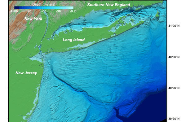
Depth topography of the NY bight approaching the Hudson Canyon dropoff.
The June 13 event was witnessed near shore by a fisherman and others who were dragged around by the waves. That event coincided with a derecho wind event that is suspected of blowing water out to sea.
The tsunami was recorded by buoys from Massachusetts to North Carolina, which also suggests that it was driven by the weather and not by a submarine landslide, ten Brink explained. That's because undersea landslides tend to be relatively local, and create pulses of energy that can make tsunamis nearby, but the waves weaken very quickly with distance.
The April 11 event, on the other hand, was recorded by buoys and occurred without any unusual weather to explain it. The next logical cause is an undersea landslide. That's what sent the Okeanos Explorer to see if there has been any change in Hudson Canyon, which slices into the edge of the continental shelf about 100 miles off the coast of New Jersey and Long Island.
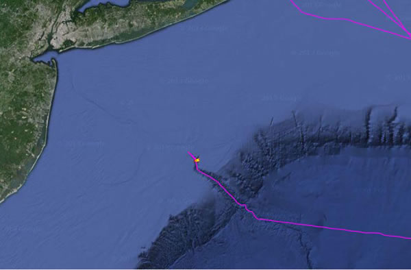
The Okeanos Explorer's recent position along the Hudson Canyon.
"We're doing another careful survey, and if we are lucky we'll see something," said Chris Moore of NOAA's Pacific Marine Environmental Laboratory where models were run of the April event that suggested Hudson Canyon may have been the tsunami source. Any changes should be easy to spot, since the last survey was just a year ago, he said. "If we are very luck we'll see a debris field."
The Okeanos Explorer uses a multibeam sonar mapping system to survey the deep ocean floor. The system uses a number of transducers pointing at different angles on either side of the ship to create a swath of signals and create 3-D maps. The ship's instruments can even penetrate some sediments and detect some features below the ocean floor, Moore explained.
Since the Okeanos Explorer conducts research (which can be watched live online) around the world, it was just good luck the ship was only a few hundred miles away when the events took place. And if that luck holds, there could soon be more to tell about the mysterious tsunami event.(Jun 28, 2013 08:30 AM ET // by Larry O'Hanlon)