Volcanic Lava Viewed from Space
Erupting volcanoes are best viewed from a distance, as the recent deadly tragedy on Mount Mayon in the Philippines proves. In the case of Paluweh volcano, the ideal spot to see the eruption was from 705 kilometers (438 miles) above the Earth.
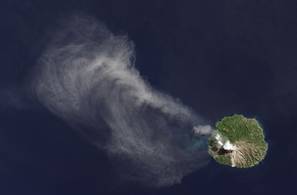
On April 29, the Landsat Data Continuity Mission satellite orbited over Indonesia’s Flores Sea and snapped shots of Paluweh, a volcanic island. Smoke and ash drifted far out to sea from the 5-mile-wide-island. The billowing ash hid the lava flowing from the heart of the volcano.
A thermal imaging camera on the satellite allowed NASA and U.S Geological Survey scientists to safely peek beneath the volcanic cloud at the glow of lava spewing from the volcano.
The satellite’s Thermal Infrared Sensor (TIRS) peered beneath the plume. NASA engineers had configured the sensor to distinguish the actual lava hotspot from the radiant heat it produced. The satellite could detected differences in temperature as small as one-tenth of a degree Celsius. This allowed scientists to accurately view the lava flow from the safety of a control room.
Volcanic Lava Viewed from Space
“We can image the white, representing the very hot lava, and right next to it we image the gray and black from the cooler surrounding ash,” said Betsy Forsbacka, TIRS instrument manager at NASA’s Goddard Space Flight Center in a press release. “It’s exciting that we’re imaging such diverse thermal activity so well.”
IMAGE 1: An ash plume drifts from Paluweh volcano in Indonesia in this image, taken April 29, 2013 from the Landsat Data Continuity Misison’s Operational Land Imager instrument.
IMAGE 2: A bright white hot spot, surrounded by cooler dark ash clouds, shows the volcanic activity at Paluweh volcano in the Flores Sea, Indonesia. This thermal image was taken by the Landsat Data Continuity Mission’s Thermal Infrared Sensor on April 29, 2013.(May 7, 2013 09:24 AM ET // by Tim Wall)