Found: Africa's Lost Mega Lake
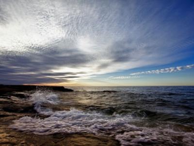
Lake Superior today. An ancient lake in Africa would have been more than half the size of the majestic lake.
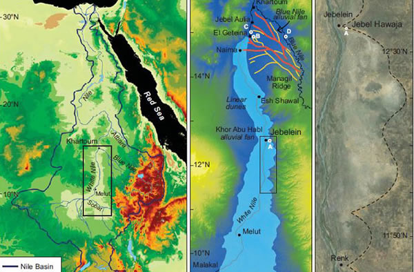
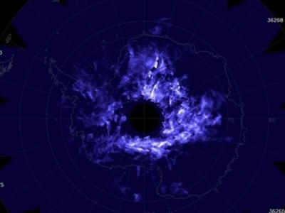
A: The entire Nile River watershed. B: Reconstruction of White Nile mega lake in Sudan. The letters show where samples were collected. C: Maps showing a portion of eastern shoreline of the mega lake.
The arid White Nile Valley in Africa was not just a lot wetter in the past, it was home to one of the largest freshwater lakes in the world, report scientists in a newly released study.
If they are right the lake last existed before the start of the most recent ice age, or glacial period, and extended 100 miles farther south than proposed by previous researchers. It also held twice as much water as previously thought and rivaled the size of today's Great Lakes of North America.
The White Nile connects the lower Nile to its source at Lake Victoria to the south. For years scientists have been curious about what appear to be ancient lake shores way up on the hills around the current White Nile Valley. Previous research was limited to rough estimates of the size of the lake based on maps that hadn't very accurate elevation information. There were also no clues to how long ago the lake existed.
The new study, published in the January issue of the journal Geology, solves all that by using highly accurate data from the Shuttle Radar Topography Mission to map out the lake level all around the valley.
To date the shoreline, as well as river channels that helped the nearby Blue Nile back-up and fill the lake, the scientists employed a rare but naturally occurring soil element -- beryllium-10 -- which is created at a known rate over the millenniums by cosmic rays raining down into Earth's atmosphere. That pegged the date of the lake to at least 109,000 years ago.
"What I think really clinches it is that the Blue Nile was further south than it is now," said the University of Exeter's Timothy Barrows, the lead author on the paper.
He explains that the most likely cause for the lake to have grown so large is torrential monsoon rains of a dramatically different climate regime which flooded not only the White Nile but the Blue Nile to the east. Dating of the ancient abandoned drainage channels from the Blue Nile suggest that that branch of the Nile once flowed so heavily it might have backed up the White Nile to make a lake of more than 45,000 square kilometers (17,000 square miles). No dams required.
"It's in the same ballpark as the Great Lakes (of North America)," said Nile lake researcher Ted Maxwell of the Smithsonian Institution, who was not involved in the latest study. "It would be like the Hoover Dam on the Colorado River, only naturally."
To compare, the White Nile mega lake would have been more than half the size of Lake Superior, or, put another way, larger than the combined areas of Lake Erie and Lake Ontario.
"One hundred and ten thousand years ago was very close to when it was very warm and sea level was six meters higher," said Barrows. That created a local climate very different from the desert seen today.
It's also a little confusing, because it was during the glacial period that followed this wet, interglacial time on the Nile that North America saw some of its mega lakes form -- like those that once existed in Utah, Nevada and California.
In other words, the warm climate between ice ages flooded the Nile, but dried up North America. And during the last glacial period the Nile's watershed dried while glaciers filled up the great inland seas of North America.(Jan 15, 2014 02:00 PM ET // by Larry O'Hanlon)