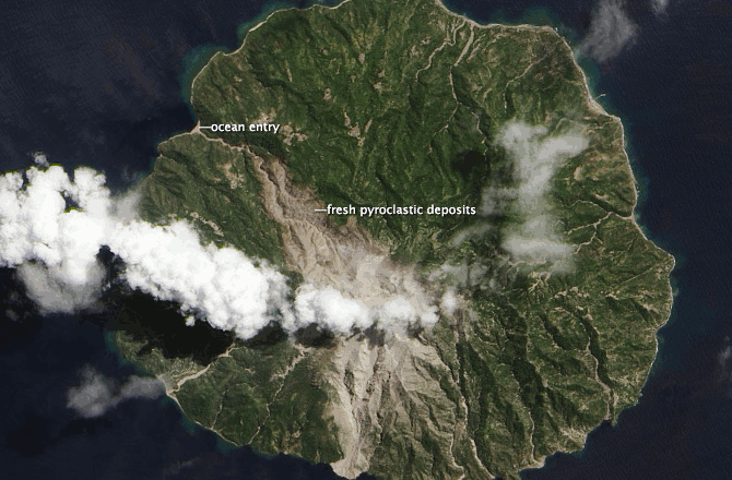
Deadly Eruptions on Tiny Paradise Island
NASA Earth Observatory images by Jesse Allen and Robert Simmon, using Landsat 8 data from the USGS Earth Explorer.
It’s a picture-perfect volcanic island, but it’s been misbehaving rather a lot lately. A new scar on the north side of Paluweh Island in Indonesia is seen in these month-apart, before-and-after eruptions images from Aug. 3 and Sept. 4. The one with the cloudy plume is the Sept. 4 image, but even the Aug. 3 image shows evidence of an ongoing eruption ― the thin blanket of ash northwest of the summit, for instance.
The more obvious feature in the Sept. 4 image is murderous pyroclastic flow to the north of the 2,870-foot (875-meter) summit. This kind of flow moves fast and is comprised of fast-moving volcanic hot ash, gas and rocks. In this case it followed a valley all the way down to the ocean. As a result of all this, the Indonesian government is stepping up efforts to evacuate Paluweh.
Both images, from NASA’s Earth Observatory, are natural-color satellite images collected by Landsat 8 and a reminder of the fickle nature of volcanoes. Since the current eruption of Paluweh (also known as Rokatenda or Palue) began in late 2012, debris and ash had mainly flowed south from the summit. On August 10, 2013, a small eruption deposited material to the north and killed five people.(Sep 12, 2013 06:51 AM ET // by Larry O'Hanlon)