On Everest Anniversary, Clarion Call for Its Glaciers
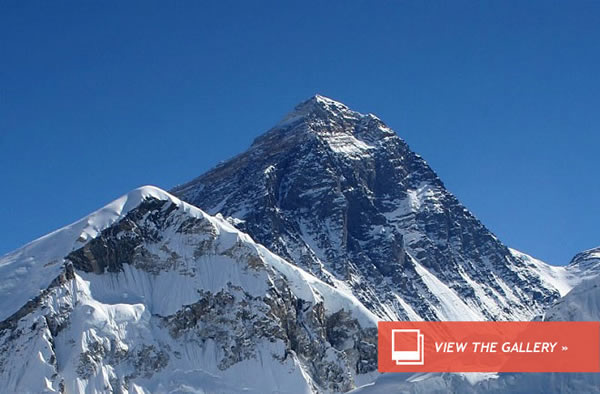
On Everest Anniversary, Clarion Call for Its Glaciers
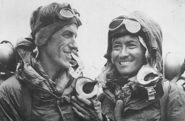
Tenzing Norgay with Edmund Hillary after their historic climb of Mt.
In 1983, American explorer David Breashears had just completed his first ascent of Mount Everest when, walking around Base Camp with understandable exhilaration, he encountered none other than Sir Edmund Hillary.
The Everest rookie naturally regarded the pioneer ― who, with Tenzing Norgay, made the first ascent 60 years ago today ― with reverence, and promptly began regaling the veteran, who was an honorary member of the expedition, with his impressions of reaching the summit.
“He very kindly said to me after maybe an hour, ‘David, someday you’ll learn to turn your eyes from the summit and look into the valleys,’” Breashears recalls 30 years later.
But, Breashears freely admits, it took almost a quarter-century before he truly understood what Hillary was telling him. In 2007, when filming a piece for the PBS show “Frontline” on the impact of climate change on Himalayan glaciers, he stood at a point overlooking Everest’s Rongbuk Glacier and compared his view with an image that had been captured by British explorer George Mallory from the same spot in 1921. What he saw ― a glacier massively diminished from the one recorded by Mallory ― stunned him.
“I pulled out that black and white photo and looked up there and took a picture and I was really shocked at what I saw, and even more astonished at my lack of knowledge at what was happening in this great mountain range,” he recalls.
Across almost the entirety of the mountain range, Himalayan glaciers are in retreat. (The picture is slightly less clear to the west and in the adjacent Karakoram range.) A recent study by a team from the University of Milan found that glaciers in the Mount Everest region have shrunk by 13 percent in the last 50 years and that the majority of the glaciers in the national park are retreating at an increasing rate.
That’s of significance not just for the glaciers’ inherent value, or for the drop in albedo that would result from a decrease in the third-largest mass of glacial ice on Earth, but because the glaciers of the Himalayas are the source of some of the world’s largest rivers, including the Indus, Ganges, Brahmaputra, Yangtze and Yellow Rivers, and are thus of vital import to the billion-plus inhabitants of those rivers’ watersheds.
Concerned by what he had seen in 2007, Breashears founded GlacierWorks, a small nonprofit, to spread the word, and returned to the region to take additional matching photographs of other, long-ago-documented glaciers.
As the project progressed, the technology became ever more sophisticated, and Breashears, who, as well as a mountaineer is a documentary filmmaker with four Emmy Awards and an IMAX movie to his credit, found that “our goal and our mission was not only to try and bring attention to what was happening at the roof of the world and what was happening to the glaciers, but we wanted to do it in a way that would engage a younger audience that is becoming increasingly used to very powerful web-based tools. So we thought, ‘Let’s take this a step further,’ and see how people could become more aware of the topography and the landscape and put it in context.”
The result was a collaboration with Internet Explorer that has yielded a truly spectacular website ― really, more of an online interactive experience ― that launches today.
One of the keys to the site, says Internet Explorer’s Roger Capriotti, is software developed by Bing called the Panorama Viewer. “We’ve taken David’s great imagery, converted it into website code, and then the Panorama Viewer gives us the ability to pinch and zoom and get into incredible detail.”
Structured around a trek from the Nepalese village of Lukla, home to the Tenzing-Hillary Airport and the start of most Everest expeditions, to the very top of the mountain, the site is a series of stunning gigapixel and high-resolution panoramas which, when zoomed into, reveal surprising secrets.
A beautiful view of the Khumbu Glacier stitched together, says Capriati, from 457 high-resolution images, yields seemingly hundreds of brightly-colored tents of the Everest Base Camp. Scroll up and zoom in again, and there are mountaineers beginning the long trek up the mountain.
The more you zoom in, the more Easter egg-like surprises reveal themselves: a horse by a tree in a monastery, for example, or a video of a bazaar. Although it functions across all platforms, the site’s full impact can truly be felt on touch screen-enabled browsers and devices: mouse clicks work just fine, but these are images that yearn to be scrolled, pinched and zoomed.
As Capriotti says, “the site feels like it’s an app. You have to remind yourself it’s a website and not an application by pulling up the address bar.”
A user can either navigate by clicking on the designated stages along the trek, or by scrolling through and exploring the images at will, unearthing hidden gems along the way thanks to a software developed by Microsoft Research called Rich Interactive Narrative, or RIN.
And of course, after being immersed in stunning Everest vistas, even to the point of a flight up to the summit itself, users can explore Breashears’ matching photographs and see for themselves how the landscape has changed.
“We’re very excited about this,” says Capriotti. “The goal of the site was to spur a new generation of explorers and learners to experience Everest, to ask questions about global change and spark a conversation about what’s happening on our planet.”
Breashears hopes that it will be just the start, that not only will he able to add imagery from other mountains in the region, but also that others will be able to contribute.
“We’ve already had a lot of interest from students and graduate students in glaciology or geology, higher-altitude physiology, many fields, who want to be a part of the project, to add to the science, and who want to bring their own material to it,” he says. “I guess you’d call it user-generated content. Because they’re in the field, and they are funded to be in the field.”
People at home around the world being able to use hand-held devices to explore the Himalayas in depth without leaving their living rooms, and to see for themselves the fact that the mountains’ glaciers are retreating.
It is, on every level, a world that would have been inconceivable when George Mallory took his photographs in 1921, and even to Hillary and Tenzing as they stood atop the summit 60 years ago today.(May 29, 2013 08:37 AM ET // by Kieran Mulvaney)