Satellite Watches Rim Fire Scorch Yosemite's Edge
Satellite Watches Rim Fire Scorch Yosemite's Edge
Firefighters, aircraft and even drones have been deployed to battle California’s sixth largest wildfire in history, but to get the best perspective of the destruction being wreaked by this natural disaster it’s best to look down from orbit.
The Rim Fire has been raging since Aug. 17 and has now spread to 192,000 acres, or 300 square miles, quarter of which is now within the boundary of Yosemite National Park. The wildfire has also threatened a key reservoir that supplies millions of people throughout the San Francisco area.
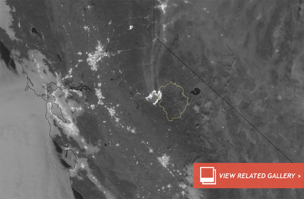
To monitor the fire’s spread, the Visible Infrared Imaging Radiometer Suite (VIIRS) onboard the NASA/NOAA Suomi NPP satellite has been employed so the full scale of the wildfire can be realized.
From NASA’s Earth Observatory website:
The VIIRS day-night band is extremely sensitive to low light, making it possible to see the fire front from space at night. The brightest, most intense parts of the fire glow white, exceeding the brightness of the lights of Reno, Nevada, to the north. Pale gray smoke streams away from the fire, generally to the north.
The progression of the wildfire is dramatic, as shown by a series of observations taken from Aug. 23-26.
To keep up to date with news on the Rim Fire’s spread, keep referring back to the DNews Storm Tracker.
Image: VIIRS observation of the Rim Fire’s perimeter on Aug. 26. Credit: NASA/NOAA/Suomi NPP/VIIRS(Aug 30, 2013 08:15 PM ET // by Ian O'Neill)